Notice to Mariners
Champlain Canal – Lock C9 Kingsbury
June 29, 2016
Mariners are advised of a short-term canal closure on the Champlain Canal immediately north of Lock C9 in Kingsbury from 10am-2pm on Thursday, June 30th due to channel maintenance. Plan itineraries accordingly.
Chart 14786 C-7 showing the affected area can be found at http://www.canals.ny.gov/navinfo/charts/14786c07r.png.
Features along the Champlain Canal are listed by mileage at http://www.canals.ny.gov/navinfo/navinfo.cgi?waterway=champlain.
Aucun message portant le libellé Canal Champlain. Afficher tous les messages
Aucun message portant le libellé Canal Champlain. Afficher tous les messages
jeudi 30 juin 2016


dimanche 18 octobre 2015
AVIS AUX NAVIGATEURS - CANAL CHAMPLAIN
All mariners are advised that the upper Hudson River dredging project, administered by the United States Environmental Protection Agency (EPA) and General Electric (GE), will be in progress during the 2015 Navigation Season between the confluence of the Mohawk River and Lock C-8 in Fort Edward. The dredging operations are lighted, have day shapes and arrow boards displayed. Additional informational signs have been posted in the project area. Boaters should follow all instructions as indicated.
All boaters must contact the Vessel Traffic Center on VHF Channel 18A for transit information through the project area.
Activities Planned for the Week of October 19, 2015:
•Barge operations immediately south of Lock C-8.
•Barge operations immediately north of Lock C-5.
•Barge operations in the vicinity of buoy Red 60.
•Barge operations in the vicinity of buoy Red 212.
•Backfill operations outside navigation channel south of buoy Red 56.
•Buoys used to aid contractor located just outside the navigational channel are located south of buoy Red 60.
•Buoys used to aid contractor located outside the navigational channel are located south of buoy Red 62A.
•Buoy used to aid contractor located outside the navigational channel is located just south of buoy Red 64.
•Buoy used to aid contractor located outside the navigational channel is located near buoy Red 78.
•Buoy used to aid contractor located outside the navigational channel is located just north of buoy Green 83.
Note: Orange colored round (Norwegian) buoys are special use buoys for the dredging project and should not to be mistaken for navigational aids. Also, additional uncharted red & green navigational aids have been placed to help guide vessels through the project.
PASS WITH CAUTION - NO WAKE ZONE
Speed limits between the confluence of the Mohawk River and Lock C-8 will be 5 mph in all work zones. In addition, please be mindful of your wakes and when approaching work platforms, stop all forward motion and proceed at a “No-Wake” speed. Local and state marine patrols will enforce posted speed limits.
For any questions related to the dredging project, call the EPA at (518) 747-4389 or GE at (518) 792-4087.
Features along the Champlain Canal are listed by mileage at http://www.canals.ny.gov/navinfo/navinfo.cgi?waterway=champlain.
For updates and information, please visit Canals.NY.gov or follow us on Facebook or Twitter
08:11:02AM 10/18/15
mardi 29 septembre 2015
AVIS AUX NAVIGATEURS - CANAL CHAMPLAIN
Notice to Mariners
Eastern & Central New York Sections of the New York State Canal System
September 29, 2015
Mariners are advised that temporary closures of the Canal System are possible later this week due to heavy rainfall in the forecast. More prolonged closures of certain sections of the Canal System could result from the impacts of Tropical Storm Joaquin this coming weekend, depending on the storm’s track and the amount of rainfall that actually occurs.
Mariners are advised that elevated water levels, reduced bridge clearances, excessive current, and debris may be encountered after heavy rainfall even in sections of the Canal System which remain open.
Additional updates will be provided as forecasts change.
For updates and information, please visit Canals.NY.gov or follow us on Facebook or Twitter.
10:54:23AM 9/29/15
Please do not reply to this email. This email is generated by an automatic system that does not accept incoming email. Should you have questions, comments or concerns regarding this service, please contact the Canal Corporation at our contact form
Eastern & Central New York Sections of the New York State Canal System
September 29, 2015
Mariners are advised that temporary closures of the Canal System are possible later this week due to heavy rainfall in the forecast. More prolonged closures of certain sections of the Canal System could result from the impacts of Tropical Storm Joaquin this coming weekend, depending on the storm’s track and the amount of rainfall that actually occurs.
Mariners are advised that elevated water levels, reduced bridge clearances, excessive current, and debris may be encountered after heavy rainfall even in sections of the Canal System which remain open.
Additional updates will be provided as forecasts change.
For updates and information, please visit Canals.NY.gov or follow us on Facebook or Twitter.
10:54:23AM 9/29/15
Please do not reply to this email. This email is generated by an automatic system that does not accept incoming email. Should you have questions, comments or concerns regarding this service, please contact the Canal Corporation at our contact form
vendredi 18 septembre 2015
AVIS AUX NAVIGATEURS - CANAL CHAMPLAIN
Notice to Mariners
Champlain Canal – Fort Edward Yacht Basin
September 18, 2015
Mariners are advised that the Fort Edward Yacht Basin – and Yacht Basin channel from Buoy G "225" to the Fort Edward Terminal – will be closed to all recreational and vessel traffic beginning at 7 am on Saturday, September 19 due to marine operations. All non-project vessels will be prohibited from docking at the Fort Edward Terminal or navigating from Buoy 225 upstream until further notice.
A subsequent Notice to Mariners will provide a schedule for the reopening of this area to vessel traffic.
Marinas and Public Docks are listed at http://www.canals.ny.gov/boating/marinas.cgi and on the Canal Map at http://www.canals.ny.gov/maps/index.html?layer=marinas.
Chart 14786 C-6 covering the affected area can be found at http://www.canals.ny.gov/navinfo/charts/14786c06r.png.
Features along the Fort Edward Yacht Basin are listed by mileage at http://www.canals.ny.gov/navinfo/navinfo.cgi?waterway=fortedward.
For updates and information, please visit Canals.NY.gov or follow us on Facebook or Twitter.
03:07:49PM 9/18/15
Champlain Canal – Fort Edward Yacht Basin
September 18, 2015
Mariners are advised that the Fort Edward Yacht Basin – and Yacht Basin channel from Buoy G "225" to the Fort Edward Terminal – will be closed to all recreational and vessel traffic beginning at 7 am on Saturday, September 19 due to marine operations. All non-project vessels will be prohibited from docking at the Fort Edward Terminal or navigating from Buoy 225 upstream until further notice.
A subsequent Notice to Mariners will provide a schedule for the reopening of this area to vessel traffic.
Marinas and Public Docks are listed at http://www.canals.ny.gov/boating/marinas.cgi and on the Canal Map at http://www.canals.ny.gov/maps/index.html?layer=marinas.
Chart 14786 C-6 covering the affected area can be found at http://www.canals.ny.gov/navinfo/charts/14786c06r.png.
Features along the Fort Edward Yacht Basin are listed by mileage at http://www.canals.ny.gov/navinfo/navinfo.cgi?waterway=fortedward.
For updates and information, please visit Canals.NY.gov or follow us on Facebook or Twitter.
03:07:49PM 9/18/15
vendredi 11 septembre 2015
CANAL CHAMPLAIN - CÉDULE D'AUTOMNE
Mariners are advised that the New York State Canal System has moved into its late season operating hours. All locks and lift bridges will be operated from 7:00 am until 5:00 pm daily through the last day of the season, November 18th.
Vessels will be admitted through structures if arriving prior to scheduled closing. Vessels arriving at Lock CS-2/3 in Seneca Falls or Lock E-34/35 in Lockport from either direction prior to scheduled closing will be admitted through both chambers. Vessels arriving westbound at Lock E-21 in New London or arriving eastbound at Lock E-22 in Verona prior to scheduled closing will be admitted through both locks. Vessels arriving southbound at Lock C-4 in Stillwater or arriving northbound at Lock C-3 in Mechanicville prior to scheduled closing will be admitted through both locks. Vessels arriving at the Waterford Flight from either direction prior to scheduled closing will be admitted through the entire Flight.
24-hour service is available to commercial vessels such as tour boats, tugboats, charter boats, cruise ships, and hire-boats operating on the Canal System. Registered commercial operators should call (518) 471-5014 during regular business hours and (518) 461-0942 after hours to make arrangements for lock and lift bridge service outside of the Canal’s regular operating schedule.
Details about operating hours can be found at http://www.canals.ny.gov/boating/hours.html.
Vessels will be admitted through structures if arriving prior to scheduled closing. Vessels arriving at Lock CS-2/3 in Seneca Falls or Lock E-34/35 in Lockport from either direction prior to scheduled closing will be admitted through both chambers. Vessels arriving westbound at Lock E-21 in New London or arriving eastbound at Lock E-22 in Verona prior to scheduled closing will be admitted through both locks. Vessels arriving southbound at Lock C-4 in Stillwater or arriving northbound at Lock C-3 in Mechanicville prior to scheduled closing will be admitted through both locks. Vessels arriving at the Waterford Flight from either direction prior to scheduled closing will be admitted through the entire Flight.
24-hour service is available to commercial vessels such as tour boats, tugboats, charter boats, cruise ships, and hire-boats operating on the Canal System. Registered commercial operators should call (518) 471-5014 during regular business hours and (518) 461-0942 after hours to make arrangements for lock and lift bridge service outside of the Canal’s regular operating schedule.
Details about operating hours can be found at http://www.canals.ny.gov/boating/hours.html.
lundi 13 juillet 2015
CANAL CHAMPLAIN - Avis aux navigateurs
Notice to Mariners
Champlain Canal - Upper Hudson River Dredging Project
July 13, 2015
All mariners are advised that the upper Hudson River dredging project, administered by the United States Environmental Protection Agency (EPA) and General Electric (GE), will be in progress during the 2015 Navigation Season between the confluence of the Mohawk River and Lock C-8 in Fort Edward. The dredging operations are lighted, have day shapes and arrow boards displayed. Additional informational signs have been posted in the project area. Boaters should follow all instructions as indicated.
All boaters must contact the Vessel Traffic Center on VHF Channel 18A for transit information through the project area.
Activities Planned for the Week of July 13, 2015:
•Barge unloading operations immediately south of Lock C-8.
•Barge operations immediately north of Lock C-5.
•Barge operations in the vicinity of buoy Red 60.
•No wake buoys the land cut north of Lock C-6 marking the no wake zone established in the vicinity of the barge unloading areas.
•Dredge operations in the vicinity of buoy Red 48.
•Backfill operations in the vicinity of buoy Red 56.
•Backfill operations in the vicinity of buoy Red 62.
•Dredge activities outside navigation channel in vicinity of buoy Red 190.
•Buoys used to aid dredge contractor located outside the navigational channel are located north of buoy Red 56.
•Buoys used to aid dredge contractor located just outside the navigational channel are located south of buoy Red 60.
•Buoys used to aid dredge contractor located outside the navigational channel are located south of buoy Red 62A.
•Buoy used to aid dredge contractor located outside the navigational channel is located just south of buoy Red 64A.
Note: Orange colored round (Norwegian) buoys are special use buoys for the dredging project and should not to be mistaken for navigational aids. Also, additional uncharted red & green navigational aids have been placed to help guide vessels through the project.
PASS WITH CAUTION - NO WAKE ZONE
Speed limits between the confluence of the Mohawk River and Lock C-8 will be 5 mph in all work zones. In addition, please be mindful of your wakes and when approaching work platforms, stop all forward motion and proceed at a “No-Wake” speed. Local and state marine patrols will enforce posted speed limits.
For any questions related to the dredging project, call the EPA at (518) 747-4389 or GE at (518) 792-4087.
Features along the Champlain Canal are listed by mileage at http://www.canals.ny.gov/navinfo/navinfo.cgi?waterway=champlain.
For updates and information, please call 1-800-4CANAL4 or visit Canals.NY.gov.
07:46:41AM 7/13/15
Champlain Canal - Upper Hudson River Dredging Project
July 13, 2015
All mariners are advised that the upper Hudson River dredging project, administered by the United States Environmental Protection Agency (EPA) and General Electric (GE), will be in progress during the 2015 Navigation Season between the confluence of the Mohawk River and Lock C-8 in Fort Edward. The dredging operations are lighted, have day shapes and arrow boards displayed. Additional informational signs have been posted in the project area. Boaters should follow all instructions as indicated.
All boaters must contact the Vessel Traffic Center on VHF Channel 18A for transit information through the project area.
Activities Planned for the Week of July 13, 2015:
•Barge unloading operations immediately south of Lock C-8.
•Barge operations immediately north of Lock C-5.
•Barge operations in the vicinity of buoy Red 60.
•No wake buoys the land cut north of Lock C-6 marking the no wake zone established in the vicinity of the barge unloading areas.
•Dredge operations in the vicinity of buoy Red 48.
•Backfill operations in the vicinity of buoy Red 56.
•Backfill operations in the vicinity of buoy Red 62.
•Dredge activities outside navigation channel in vicinity of buoy Red 190.
•Buoys used to aid dredge contractor located outside the navigational channel are located north of buoy Red 56.
•Buoys used to aid dredge contractor located just outside the navigational channel are located south of buoy Red 60.
•Buoys used to aid dredge contractor located outside the navigational channel are located south of buoy Red 62A.
•Buoy used to aid dredge contractor located outside the navigational channel is located just south of buoy Red 64A.
Note: Orange colored round (Norwegian) buoys are special use buoys for the dredging project and should not to be mistaken for navigational aids. Also, additional uncharted red & green navigational aids have been placed to help guide vessels through the project.
PASS WITH CAUTION - NO WAKE ZONE
Speed limits between the confluence of the Mohawk River and Lock C-8 will be 5 mph in all work zones. In addition, please be mindful of your wakes and when approaching work platforms, stop all forward motion and proceed at a “No-Wake” speed. Local and state marine patrols will enforce posted speed limits.
For any questions related to the dredging project, call the EPA at (518) 747-4389 or GE at (518) 792-4087.
Features along the Champlain Canal are listed by mileage at http://www.canals.ny.gov/navinfo/navinfo.cgi?waterway=champlain.
For updates and information, please call 1-800-4CANAL4 or visit Canals.NY.gov.
07:46:41AM 7/13/15
vendredi 26 juin 2015
CANAL CHAMPLAIN - Avis aux Navigateurs
Notice to Mariners
New York State Canal System
June 26, 2015
Mariners are advised that Governor Andrew M. Cuomo has announced that there will be no charge for recreational vessels traveling through locks and lift bridges on the NYS Canal System on Saturday, June 27 and Sunday, June 28. This "free weekend" of boating on New York's Canals is being held in conjunction with New York State's Free Fishing Weekend.
Holders of 10-day and 2-day passes already issued will be credited these days, and passes will be extended for 2 days. Travelers on the Canal this weekend only will not have to purchase a pass at all.
The Canal Corporation encourages everyone to navigate with caution and have a safe and enjoyable boating experience this weekend.
A map showing boat launch access to the New York State Canal System, along with nearby New York State Thruway Exits, can be found at http://www.canals.ny.gov/maps/index.html?layer=ramp,interchanges.
For updates and information, please visit Canals.NY.gov or call 1-800-4CANAL4.
01:14:54PM 6/26/15
New York State Canal System
June 26, 2015
Mariners are advised that Governor Andrew M. Cuomo has announced that there will be no charge for recreational vessels traveling through locks and lift bridges on the NYS Canal System on Saturday, June 27 and Sunday, June 28. This "free weekend" of boating on New York's Canals is being held in conjunction with New York State's Free Fishing Weekend.
Holders of 10-day and 2-day passes already issued will be credited these days, and passes will be extended for 2 days. Travelers on the Canal this weekend only will not have to purchase a pass at all.
The Canal Corporation encourages everyone to navigate with caution and have a safe and enjoyable boating experience this weekend.
A map showing boat launch access to the New York State Canal System, along with nearby New York State Thruway Exits, can be found at http://www.canals.ny.gov/maps/index.html?layer=ramp,interchanges.
For updates and information, please visit Canals.NY.gov or call 1-800-4CANAL4.
01:14:54PM 6/26/15
vendredi 29 mai 2015
CANAL CHAMPLAIN - AVIS AUX NAVIGATEURS
Notice to Mariners
Champlain Canal - Upper Hudson River Dredging Project
May 29, 2014
All mariners are advised that the upper Hudson River dredging project, administered by the United States Environmental Protection Agency (EPA) and General Electric (GE), will be in progress during the 2015 Navigation Season between the confluence of the Mohawk River and Lock C-8 in Fort Edward. The dredging operations are lighted, have day shapes and arrow boards displayed. Additional informational signs have been posted in the project area. Boaters should follow all instructions as indicated.
All boaters must contact the Vessel Traffic Center on VHF Channel 18A for transit information through the project area.
Activities Planned for the Week of June 1, 2015:
•Barge unloading operations immediately south of Lock C-8.
•Barge operations immediately north of Lock C-5.
•Barge operations in the vicinity of buoy Red 60.
•No wake buoys the land cut north of Lock C-6 marking the no wake zone established in the vicinity of the barge unloading areas.
•Dredge operations between approximately buoy Red 10 and Red 14.
•Dredge operations in the vicinity of buoy Red 48.
•Dredge operations in the vicinity of buoy Red 56.
•Dredge operations in the vicinity of buoy Red 62.
•Lighted Norwegian buoy indicating submerged pump outside the navigational channel located approximately 400’ north of buoy Green 55.
•Buoys used to aid dredge contractor located outside the navigational channel are located north of buoy Red 56.
•Buoys used to aid dredge contractor located just outside the navigational channel are located south of buoy Red 60.
•Buoys used to aid dredge contractor located outside the navigational channel are located south of buoy Red 62A.
Note: Orange colored round (Norwegian) buoys are special use buoys for the dredging project and should not to be mistaken for navigational aids. Also, additional uncharted red & green navigational aids have been placed to help guide vessels through the project.
PASS WITH CAUTION - NO WAKE ZONE
Speed limits between the confluence of the Mohawk River and Lock C-8 will be 5 mph in all work zones. In addition, please be mindful of your wakes and when approaching work platforms, stop all forward motion and proceed at a “No-Wake” speed. Local and state marine patrols will enforce posted speed limits.
For any questions related to the dredging project, call the EPA at (518) 747-4389 or GE at (518) 792-4087.
Features along the Champlain Canal are listed by mileage at http://www.canals.ny.gov/navinfo/navinfo.cgi?waterway=champlain.
For updates and information, please call 1-800-4CANAL4 or visit Canals.NY.gov.
09:00:38AM 5/29/15
Champlain Canal - Upper Hudson River Dredging Project
May 29, 2014
All mariners are advised that the upper Hudson River dredging project, administered by the United States Environmental Protection Agency (EPA) and General Electric (GE), will be in progress during the 2015 Navigation Season between the confluence of the Mohawk River and Lock C-8 in Fort Edward. The dredging operations are lighted, have day shapes and arrow boards displayed. Additional informational signs have been posted in the project area. Boaters should follow all instructions as indicated.
All boaters must contact the Vessel Traffic Center on VHF Channel 18A for transit information through the project area.
Activities Planned for the Week of June 1, 2015:
•Barge unloading operations immediately south of Lock C-8.
•Barge operations immediately north of Lock C-5.
•Barge operations in the vicinity of buoy Red 60.
•No wake buoys the land cut north of Lock C-6 marking the no wake zone established in the vicinity of the barge unloading areas.
•Dredge operations between approximately buoy Red 10 and Red 14.
•Dredge operations in the vicinity of buoy Red 48.
•Dredge operations in the vicinity of buoy Red 56.
•Dredge operations in the vicinity of buoy Red 62.
•Lighted Norwegian buoy indicating submerged pump outside the navigational channel located approximately 400’ north of buoy Green 55.
•Buoys used to aid dredge contractor located outside the navigational channel are located north of buoy Red 56.
•Buoys used to aid dredge contractor located just outside the navigational channel are located south of buoy Red 60.
•Buoys used to aid dredge contractor located outside the navigational channel are located south of buoy Red 62A.
Note: Orange colored round (Norwegian) buoys are special use buoys for the dredging project and should not to be mistaken for navigational aids. Also, additional uncharted red & green navigational aids have been placed to help guide vessels through the project.
PASS WITH CAUTION - NO WAKE ZONE
Speed limits between the confluence of the Mohawk River and Lock C-8 will be 5 mph in all work zones. In addition, please be mindful of your wakes and when approaching work platforms, stop all forward motion and proceed at a “No-Wake” speed. Local and state marine patrols will enforce posted speed limits.
For any questions related to the dredging project, call the EPA at (518) 747-4389 or GE at (518) 792-4087.
Features along the Champlain Canal are listed by mileage at http://www.canals.ny.gov/navinfo/navinfo.cgi?waterway=champlain.
For updates and information, please call 1-800-4CANAL4 or visit Canals.NY.gov.
09:00:38AM 5/29/15
jeudi 14 mai 2015
CANAL CHAMPLAIN - Whitehall - mise à jour
Notice to Mariners
Champlain Canal – Whitehall
May 14, 2015
Mariners are advised that Lock C-12 in Whitehall has reopened. The entire New York State Canal System is open to navigation.
Chart 14786 C-10 covering the affected area can be found at http://www.canals.ny.gov/navinfo/charts/14786c10.png.
Features along the Champlain Canal are listed by mileage at http://www.canals.ny.gov/navinfo/navinfo.cgi?waterway=champlain
For updates and information, please call 1-800-4CANAL4 or visit Canals.NY.gov.
02:22:50PM 5/14/15
Champlain Canal – Whitehall
May 14, 2015
Mariners are advised that Lock C-12 in Whitehall has reopened. The entire New York State Canal System is open to navigation.
Chart 14786 C-10 covering the affected area can be found at http://www.canals.ny.gov/navinfo/charts/14786c10.png.

Features along the Champlain Canal are listed by mileage at http://www.canals.ny.gov/navinfo/navinfo.cgi?waterway=champlain
For updates and information, please call 1-800-4CANAL4 or visit Canals.NY.gov.
02:22:50PM 5/14/15
CHAMPLAIN CANAL -WHITEHALL
Notice to Mariners
Champlain Canal – Whitehall
May 14, 2015
Mariners are advised that the west gates (upper and lower) of Lock C-12 Whitehall, are now operable. Vessels with a beam not exceeding 20' may proceed through this lock at this time. A subsequent Notice to Mariners will be issued announcing a short-term closure of this lock for repairs, followed by its full reopening.
Chart 14786 C-10 covering the affected area can be found at http://www.canals.ny.gov/navinfo/charts/14786c10.png.
Features along the Champlain Canal are listed by mileage at http://www.canals.ny.gov/navinfo/navinfo.cgi?waterway=champlain.
For updates and information, please call 1-800-4CANAL4 or visit Canals.NY.gov.
12:57:29PM 5/14/15
Champlain Canal – Whitehall
May 14, 2015
Mariners are advised that the west gates (upper and lower) of Lock C-12 Whitehall, are now operable. Vessels with a beam not exceeding 20' may proceed through this lock at this time. A subsequent Notice to Mariners will be issued announcing a short-term closure of this lock for repairs, followed by its full reopening.
Chart 14786 C-10 covering the affected area can be found at http://www.canals.ny.gov/navinfo/charts/14786c10.png.
Features along the Champlain Canal are listed by mileage at http://www.canals.ny.gov/navinfo/navinfo.cgi?waterway=champlain.
For updates and information, please call 1-800-4CANAL4 or visit Canals.NY.gov.
12:57:29PM 5/14/15
lundi 11 mai 2015
CANAL CHAMPLAIN - avis aux navigateurs
Notice to Mariners
Champlain Canal - Upper Hudson River Dredging Project
May 11, 2015
All mariners are advised that the upper Hudson River dredging project, administered by the United States Environmental Protection Agency (EPA) and General Electric (GE), will be in progress during the 2015 Navigation Season between the confluence of the Mohawk River and Lock C-8 in Fort Edward. The dredging operations are lighted, have day shapes and arrow boards displayed. Additional informational signs have been posted in the project area. Boaters should follow all instructions as indicated.
All boaters must contact the Vessel Traffic Center on VHF Channel 18A for transit information through the project area.
Activities Planned for the Week of May 11, 2015:
•Barge unloading operations immediately south of Lock C-8.
•Barge operations immediately north of Lock C-5.
•Barge operations in the vicinity of buoy Red 60.
•Dredge operations between approximately buoy Red 10 and Red 14.
•Dredge operations in vicinity of buoy Red 56.
•Lighted Norwegian buoy indicating submerged pump outside the navigational channel located approximately 400’ north of buoy Green 55.
Note: Orange colored round (Norwegian) buoys are special use buoys for the dredging project and should not to be mistaken for navigational aids. Also, additional uncharted red & green navigational aids have been placed to help guide vessels through the project.
PASS WITH CAUTION - NO WAKE ZONE
Speed limits between the confluence of the Mohawk River and Lock C-8 will be 5 mph in all work zones. In addition, please be mindful of your wakes and when approaching work platforms, stop all forward motion and proceed at a “No-Wake” speed. Local and state marine patrols will enforce posted speed limits.
For any questions related to the dredging project, call the EPA at (518) 747-4389 or GE at (518) 792-4087.
Features along the Champlain Canal are listed by mileage at http://www.canals.ny.gov/navinfo/navinfo.cgi?waterway=champlain.
For updates and information, please call 1-800-4CANAL4 or visit Canals.NY.gov.
09:39:42AM 5/11/15
Champlain Canal - Upper Hudson River Dredging Project
May 11, 2015
All mariners are advised that the upper Hudson River dredging project, administered by the United States Environmental Protection Agency (EPA) and General Electric (GE), will be in progress during the 2015 Navigation Season between the confluence of the Mohawk River and Lock C-8 in Fort Edward. The dredging operations are lighted, have day shapes and arrow boards displayed. Additional informational signs have been posted in the project area. Boaters should follow all instructions as indicated.
All boaters must contact the Vessel Traffic Center on VHF Channel 18A for transit information through the project area.
Activities Planned for the Week of May 11, 2015:
•Barge unloading operations immediately south of Lock C-8.
•Barge operations immediately north of Lock C-5.
•Barge operations in the vicinity of buoy Red 60.
•Dredge operations between approximately buoy Red 10 and Red 14.
•Dredge operations in vicinity of buoy Red 56.
•Lighted Norwegian buoy indicating submerged pump outside the navigational channel located approximately 400’ north of buoy Green 55.
Note: Orange colored round (Norwegian) buoys are special use buoys for the dredging project and should not to be mistaken for navigational aids. Also, additional uncharted red & green navigational aids have been placed to help guide vessels through the project.
PASS WITH CAUTION - NO WAKE ZONE
Speed limits between the confluence of the Mohawk River and Lock C-8 will be 5 mph in all work zones. In addition, please be mindful of your wakes and when approaching work platforms, stop all forward motion and proceed at a “No-Wake” speed. Local and state marine patrols will enforce posted speed limits.
For any questions related to the dredging project, call the EPA at (518) 747-4389 or GE at (518) 792-4087.
Features along the Champlain Canal are listed by mileage at http://www.canals.ny.gov/navinfo/navinfo.cgi?waterway=champlain.
For updates and information, please call 1-800-4CANAL4 or visit Canals.NY.gov.
09:39:42AM 5/11/15
vendredi 8 mai 2015
CANAL CHAMPLAIN - Avis aux navigateurs
Notice to Mariners
Champlain Canal – Lock 11, Comstock
May 8, 2015
Mariners are advised that the east gates (upper and lower) of Lock C-11 Comstock, are currently inoperable. Vessels with a beam not exceeding 20' may still proceed through this lock at this time. It is expected that all gates will be fully operational on Monday, May 11th.
Chart 14786 C-09 covering the affected area can be found at http://www.canals.ny.gov/navinfo/charts/14786c09l.png
Features along the Champlain Canal are listed by mileage at
http://www.canals.ny.gov/navinfo/navinfo.cgi?waterway=champlain
For updates and information, please call 1-800-4CANAL4 or visit Canals.NY.gov.
Champlain Canal – Lock 11, Comstock
May 8, 2015
Mariners are advised that the east gates (upper and lower) of Lock C-11 Comstock, are currently inoperable. Vessels with a beam not exceeding 20' may still proceed through this lock at this time. It is expected that all gates will be fully operational on Monday, May 11th.
Chart 14786 C-09 covering the affected area can be found at http://www.canals.ny.gov/navinfo/charts/14786c09l.png

Features along the Champlain Canal are listed by mileage at
http://www.canals.ny.gov/navinfo/navinfo.cgi?waterway=champlain
For updates and information, please call 1-800-4CANAL4 or visit Canals.NY.gov.
CANAL CHAMPLAIN - Avis aux navigateurs
Notice to Mariners
Champlain Canal – Mechanicville
May 8, 2015
Mariners are advised that NYSEG's dam hazard delineator (boat barrier) at Lock C-3 Mechanicville has not yet been installed. It is scheduled to be installed on Friday, May 15th.
Chart 14786 C-3 covering the affected area can be found at http://www.canals.ny.gov/navinfo/charts/14786c02r.png.
Features along the Champlain Canal are listed by mileage at http://www.canals.ny.gov/navinfo/navinfo.cgi?waterway=champlain.
For updates and information, please call 1-800-4CANAL4 or visit Canals.NY.gov.
Champlain Canal – Mechanicville
May 8, 2015
Mariners are advised that NYSEG's dam hazard delineator (boat barrier) at Lock C-3 Mechanicville has not yet been installed. It is scheduled to be installed on Friday, May 15th.
Chart 14786 C-3 covering the affected area can be found at http://www.canals.ny.gov/navinfo/charts/14786c02r.png.

Features along the Champlain Canal are listed by mileage at http://www.canals.ny.gov/navinfo/navinfo.cgi?waterway=champlain.
For updates and information, please call 1-800-4CANAL4 or visit Canals.NY.gov.
jeudi 7 mai 2015
AVIS AUX NAVIGATEURS - CANAL CHAMPLAIN
Notice to Mariners
Upper Hudson River – Champlain Canal
May 7, 2015
Mariners are advised that buoy R “60” is being temporarily moved 150' north to accommodate the Upper Hudson River Dredging Project.
Chart 14786 C-2 covering the affected area can be found at http://www.canals.ny.gov/navinfo/charts/14786c02r.png.
Features along the Champlain Canal are listed by mileage at http://www.canals.ny.gov/navinfo/navinfo.cgi?waterway=champlain.
PASS WITH CAUTION - NO WAKE ZONE
Speed limits between Lock C-2 and Lock C-3 will be 5 mph in all work zones. In addition, please be mindful of your wakes and when approaching work platforms, stop all forward motion and proceed at a “No-Wake” speed. Local and state marine patrols will enforce posted speed limits.
For any questions related to the dredging project, call the EPA at (518) 747-4389 or GE at (518) 792-4087.
For updates and information, please call 1-800-4CANAL4 or visit Canals.NY.gov.
Upper Hudson River – Champlain Canal
May 7, 2015
Mariners are advised that buoy R “60” is being temporarily moved 150' north to accommodate the Upper Hudson River Dredging Project.
Chart 14786 C-2 covering the affected area can be found at http://www.canals.ny.gov/navinfo/charts/14786c02r.png.
Features along the Champlain Canal are listed by mileage at http://www.canals.ny.gov/navinfo/navinfo.cgi?waterway=champlain.
PASS WITH CAUTION - NO WAKE ZONE
Speed limits between Lock C-2 and Lock C-3 will be 5 mph in all work zones. In addition, please be mindful of your wakes and when approaching work platforms, stop all forward motion and proceed at a “No-Wake” speed. Local and state marine patrols will enforce posted speed limits.
For any questions related to the dredging project, call the EPA at (518) 747-4389 or GE at (518) 792-4087.
For updates and information, please call 1-800-4CANAL4 or visit Canals.NY.gov.
mercredi 22 avril 2015
NY STATE CANAL - OUVERTURE
Notice to Mariners
2015 Navigation Season
April 21, 2015
Mariners are advised that, conditions permitting, all portions of the New York State Canal System are scheduled to open Thursday, May 8, 2015, at 7:00 a.m. for the 2015 navigation season.
The hours of operation for the 2015 season are as follows:
•May 8 to June 3: 7:00 a.m. to 5:00 p.m.
•June 4 to September 9: 8:00 a.m. to 6:00 p.m.
•September 10 to November 18: 7:00 a.m. to 5:00 p.m.
In addition to the schedule listed above, the following locks and lift bridges will operate on demand from 7:00 am to 10:00 pm from June 4 to September 9:
•Lock C-1, Halfmoon
•Lock E-7, Niskayuna
•Lock E-23, Brewerton
•Lock O-1, Phoenix
•Lock E-24, Baldwinsville
•Main Street Lift Bridge, Fairport
•Lock E-32, Pittsford
•Lock E-33, Henrietta
•Spencerport Lift Bridge
•Adams Basin Lift Bridge
•Park Avenue Lift Bridge, Brockport
•Main Street Lift Bridge, Brockport
•Exchange Street Lift Bridge, Lockport
•Lock E-34/35, Lockport
•Lock CS-1, Cayuga
•Lock CS-2/3, Seneca Falls
•Lock CS-4, Waterloo
In addition to the structures listed above, the following lift bridges will operate on demand from 7:00 am to 6:00 pm and will also offer scheduled lifts at the times noted below from June 4 to September 19 as follows:
•Medina Lift Bridge – 6:30 pm, 9:30 pm
•Middleport Lift Bridge – 7:10 pm, 8:50 pm
•Gasport Lift Bridge – 7:50 pm, 8:10 pm
Vessels will be admitted through structures if arriving prior to scheduled closing. Vessels arriving at Lock CS-2/3 in Seneca Falls or Lock E-34/35 in Lockport from either direction prior to scheduled closing will be admitted through both chambers. Vessels arriving westbound at Lock E-21 in New London or arriving eastbound at Lock E-22 in Verona prior to scheduled closing will be admitted through both locks. Vessels arriving southbound at Lock C-4 in Stillwater or arriving northbound at Lock C-3 in Mechanicville prior to scheduled closing will be admitted through both locks. Vessels arriving at the Waterford Flight from either direction prior to scheduled closing will be admitted through the entire Flight.
24-hour service is available to commercial vessels such as tour boats, tugboats, charter boats, cruise ships, and hire-boats operating on the Canal System. Registered commercial operators should call (518) 471-5014 during regular business hours and (518) 461-0942 after hours to make arrangements for lock and lift bridge service outside of the Canal’s regular operating schedule. Requests for this service must be made at least 24 hours in advance.
For updates and information, please call 1-800-4CANAL4 or visit canals.ny.gov.
Notice to Mariners
Commercial Permits
April 22, 2015
Commercial Mariners are reminded to apply for their 2015 permits now to avoid any delays when intending to enter the New York State Canal System. Commercial permits are required for those shipping product or passengers, but not for captains delivering recreational vessels – they may use recreational passes.
Commercial permit applications can be found at http://www.canals.ny.gov/business/shipping.html.
Recreational permits can be purchased online at https://wwwapps.canals.ny.gov/store/.
For updates and information, please call 1-800-4CANAL4 or visit canals.ny.gov.
02:53:12PM 4/22/15
2015 Navigation Season
April 21, 2015
Mariners are advised that, conditions permitting, all portions of the New York State Canal System are scheduled to open Thursday, May 8, 2015, at 7:00 a.m. for the 2015 navigation season.
The hours of operation for the 2015 season are as follows:
•May 8 to June 3: 7:00 a.m. to 5:00 p.m.
•June 4 to September 9: 8:00 a.m. to 6:00 p.m.
•September 10 to November 18: 7:00 a.m. to 5:00 p.m.
In addition to the schedule listed above, the following locks and lift bridges will operate on demand from 7:00 am to 10:00 pm from June 4 to September 9:
•Lock C-1, Halfmoon
•Lock E-7, Niskayuna
•Lock E-23, Brewerton
•Lock O-1, Phoenix
•Lock E-24, Baldwinsville
•Main Street Lift Bridge, Fairport
•Lock E-32, Pittsford
•Lock E-33, Henrietta
•Spencerport Lift Bridge
•Adams Basin Lift Bridge
•Park Avenue Lift Bridge, Brockport
•Main Street Lift Bridge, Brockport
•Exchange Street Lift Bridge, Lockport
•Lock E-34/35, Lockport
•Lock CS-1, Cayuga
•Lock CS-2/3, Seneca Falls
•Lock CS-4, Waterloo
In addition to the structures listed above, the following lift bridges will operate on demand from 7:00 am to 6:00 pm and will also offer scheduled lifts at the times noted below from June 4 to September 19 as follows:
•Medina Lift Bridge – 6:30 pm, 9:30 pm
•Middleport Lift Bridge – 7:10 pm, 8:50 pm
•Gasport Lift Bridge – 7:50 pm, 8:10 pm
Vessels will be admitted through structures if arriving prior to scheduled closing. Vessels arriving at Lock CS-2/3 in Seneca Falls or Lock E-34/35 in Lockport from either direction prior to scheduled closing will be admitted through both chambers. Vessels arriving westbound at Lock E-21 in New London or arriving eastbound at Lock E-22 in Verona prior to scheduled closing will be admitted through both locks. Vessels arriving southbound at Lock C-4 in Stillwater or arriving northbound at Lock C-3 in Mechanicville prior to scheduled closing will be admitted through both locks. Vessels arriving at the Waterford Flight from either direction prior to scheduled closing will be admitted through the entire Flight.
24-hour service is available to commercial vessels such as tour boats, tugboats, charter boats, cruise ships, and hire-boats operating on the Canal System. Registered commercial operators should call (518) 471-5014 during regular business hours and (518) 461-0942 after hours to make arrangements for lock and lift bridge service outside of the Canal’s regular operating schedule. Requests for this service must be made at least 24 hours in advance.
For updates and information, please call 1-800-4CANAL4 or visit canals.ny.gov.
Notice to Mariners
Commercial Permits
April 22, 2015
Commercial Mariners are reminded to apply for their 2015 permits now to avoid any delays when intending to enter the New York State Canal System. Commercial permits are required for those shipping product or passengers, but not for captains delivering recreational vessels – they may use recreational passes.
Commercial permit applications can be found at http://www.canals.ny.gov/business/shipping.html.
Recreational permits can be purchased online at https://wwwapps.canals.ny.gov/store/.
For updates and information, please call 1-800-4CANAL4 or visit canals.ny.gov.
02:53:12PM 4/22/15
mercredi 17 septembre 2014
CANAL CHAMPLAIN - avis aux navigateurs
Notice to Mariners
Upper Hudson River – Champlain Canal
September 17, 2014
Mariners are advised that buoy R “60” is being temporarily moved 220’ north to accommodate the Upper Hudson River Dredging Project.
Chart 14786 C-2 covering the affected area can be found at http://www.canals.ny.gov/navinfo/charts/14786c02r.png.
Features along the Champlain Canal are listed by mileage at http://www.canals.ny.gov/navinfo/navinfo.cgi?waterway=champlain.
PASS WITH CAUTION - NO WAKE ZONE
Speed limits between Lock C-2 and Lock C-3 will be 5 mph in all work zones. In addition, please be mindful of your wakes and when approaching work platforms, stop all forward motion and proceed at a “No-Wake” speed. Local and state marine patrols will enforce posted speed limits.
For any questions related to the dredging project, call the EPA at (518) 747-4389 or GE at (518) 792-4087.
For updates and information, please call 1-800-4CANAL4 or visit canals.ny.gov.
06:05:46PM 9/17/14
Upper Hudson River – Champlain Canal
September 17, 2014
Mariners are advised that buoy R “60” is being temporarily moved 220’ north to accommodate the Upper Hudson River Dredging Project.
Chart 14786 C-2 covering the affected area can be found at http://www.canals.ny.gov/navinfo/charts/14786c02r.png.
Features along the Champlain Canal are listed by mileage at http://www.canals.ny.gov/navinfo/navinfo.cgi?waterway=champlain.
PASS WITH CAUTION - NO WAKE ZONE
Speed limits between Lock C-2 and Lock C-3 will be 5 mph in all work zones. In addition, please be mindful of your wakes and when approaching work platforms, stop all forward motion and proceed at a “No-Wake” speed. Local and state marine patrols will enforce posted speed limits.
For any questions related to the dredging project, call the EPA at (518) 747-4389 or GE at (518) 792-4087.
For updates and information, please call 1-800-4CANAL4 or visit canals.ny.gov.
06:05:46PM 9/17/14
dimanche 14 septembre 2014
CANAL CHAMPLAIN - Avis aux navigateurs
Notice to Mariners
Champlain Canal - Upper Hudson River Dredging Project
September 14, 2014
All mariners are advised that the upper Hudson River dredging project, administered by the United States Environmental Protection Agency (EPA) and General Electric (GE), will be in progress during the 2014 Navigation Season between Lock C-4 in Stillwater and Lock C-8 in Fort Edward. The dredging operations are lighted, have day shapes and arrow boards displayed. Additional informational signs have been posted in the project area. Boaters should follow all instructions as indicated.
All boaters must contact the Vessel Traffic Center on VHF Channel 18A for transit information through the project area.
Activities Planned for the Week of September 15, 2014:
Barge unloading operations immediately south of Lock C-8.
Barge loading operations immediately north of Lock C-5.
Project hazard buoys marking shallow water areas just outside the navigational channel are located just north of buoy Green 133.
No Wake buoys in the land cut north of Lock 6 marking the no wake zone established in the vicinity of the Isthmus Transfer Area.
Norwegian buoys indicating shallow water areas located outside the navigational channel are located between buoy Red 68 and Red 66.
Norwegian buoy used as a temporary mooring located outside the navigational channel is located between buoy Red 72 and Red 66.
Dredging operations between approximately buoy Red 80 and Green 77.
Dredging operations between approximately buoy Red 68 and Red 66.
Backfill/capping operations between approximately buoy Green 91A and Green 89.
Note: Additional uncharted red & green navigational aids have been placed to help guide vessels through the project.
PASS WITH CAUTION - NO WAKE ZONE
Speed limits between Lock C-5 and Lock C-8 will be 5 mph in all work zones. In addition, please be mindful of your wakes and when approaching work platforms, stop all forward motion and proceed at a “No-Wake” speed. Local and state marine patrols will enforce posted speed limits.
For any questions related to the dredging project, call the EPA at (518) 747-4389 or GE at (518) 792-4087.
Features along the Champlain Canal are listed by mileage at http://www.canals.ny.gov/navinfo/navinfo.cgi?waterway=champlain
For updates and information, please call 1-800-4CANAL4 or visit canals.ny.gov.
09:51:40AM 9/14/14
Champlain Canal - Upper Hudson River Dredging Project
September 14, 2014
All mariners are advised that the upper Hudson River dredging project, administered by the United States Environmental Protection Agency (EPA) and General Electric (GE), will be in progress during the 2014 Navigation Season between Lock C-4 in Stillwater and Lock C-8 in Fort Edward. The dredging operations are lighted, have day shapes and arrow boards displayed. Additional informational signs have been posted in the project area. Boaters should follow all instructions as indicated.
All boaters must contact the Vessel Traffic Center on VHF Channel 18A for transit information through the project area.
Activities Planned for the Week of September 15, 2014:
Barge unloading operations immediately south of Lock C-8.
Barge loading operations immediately north of Lock C-5.
Project hazard buoys marking shallow water areas just outside the navigational channel are located just north of buoy Green 133.
No Wake buoys in the land cut north of Lock 6 marking the no wake zone established in the vicinity of the Isthmus Transfer Area.
Norwegian buoys indicating shallow water areas located outside the navigational channel are located between buoy Red 68 and Red 66.
Norwegian buoy used as a temporary mooring located outside the navigational channel is located between buoy Red 72 and Red 66.
Dredging operations between approximately buoy Red 80 and Green 77.
Dredging operations between approximately buoy Red 68 and Red 66.
Backfill/capping operations between approximately buoy Green 91A and Green 89.
Note: Additional uncharted red & green navigational aids have been placed to help guide vessels through the project.
PASS WITH CAUTION - NO WAKE ZONE
Speed limits between Lock C-5 and Lock C-8 will be 5 mph in all work zones. In addition, please be mindful of your wakes and when approaching work platforms, stop all forward motion and proceed at a “No-Wake” speed. Local and state marine patrols will enforce posted speed limits.
For any questions related to the dredging project, call the EPA at (518) 747-4389 or GE at (518) 792-4087.
Features along the Champlain Canal are listed by mileage at http://www.canals.ny.gov/navinfo/navinfo.cgi?waterway=champlain
For updates and information, please call 1-800-4CANAL4 or visit canals.ny.gov.
09:51:40AM 9/14/14
vendredi 12 septembre 2014
CANAL CHAMPLAIN - heures d'ouverture pour l'automne
Notice to Mariners
Entire New York State Canal System
September 12, 2014
Mariners are advised that the New York State Canal System has moved into its late season operating hours. All locks and lift bridges will be operated from 7:00 am until 5:00 pm daily through the last day of the season, November 19th.
Vessels will be admitted through structures if arriving prior to scheduled closing. Vessels arriving at Lock CS-2/3 in Seneca Falls or Lock E-34/35 in Lockport from either direction prior to scheduled closing will be admitted through both chambers. Vessels arriving westbound at Lock E-21 in New London or arriving eastbound at Lock E-22 in Verona prior to scheduled closing will be admitted through both locks. Vessels arriving at the Waterford Flight from either direction prior to scheduled closing will be admitted through the entire Flight.
24-hour service is available to commercial vessels such as tour boats, tugboats, charter boats, cruise ships, and hire-boats operating on the Canal System. Registered commercial operators should call (518) 471-5014 during regular business hours and (518) 461-0942 after hours to make arrangements for lock and lift bridge service outside of the Canal’s regular operating schedule.
Details about operating hours can be found at http://www.canals.ny.gov/boating/hours.html.
For updates and information, please call 1-800-4CANAL4 or visit canals.ny.gov.
08:59:42AM 9/12/14
Entire New York State Canal System
September 12, 2014
Mariners are advised that the New York State Canal System has moved into its late season operating hours. All locks and lift bridges will be operated from 7:00 am until 5:00 pm daily through the last day of the season, November 19th.
Vessels will be admitted through structures if arriving prior to scheduled closing. Vessels arriving at Lock CS-2/3 in Seneca Falls or Lock E-34/35 in Lockport from either direction prior to scheduled closing will be admitted through both chambers. Vessels arriving westbound at Lock E-21 in New London or arriving eastbound at Lock E-22 in Verona prior to scheduled closing will be admitted through both locks. Vessels arriving at the Waterford Flight from either direction prior to scheduled closing will be admitted through the entire Flight.
24-hour service is available to commercial vessels such as tour boats, tugboats, charter boats, cruise ships, and hire-boats operating on the Canal System. Registered commercial operators should call (518) 471-5014 during regular business hours and (518) 461-0942 after hours to make arrangements for lock and lift bridge service outside of the Canal’s regular operating schedule.
Details about operating hours can be found at http://www.canals.ny.gov/boating/hours.html.
For updates and information, please call 1-800-4CANAL4 or visit canals.ny.gov.
08:59:42AM 9/12/14
lundi 8 septembre 2014
CANAL CHAMPLAIN - AUTRE AVIS AUX NAVIGATEURS
Notice to Mariners
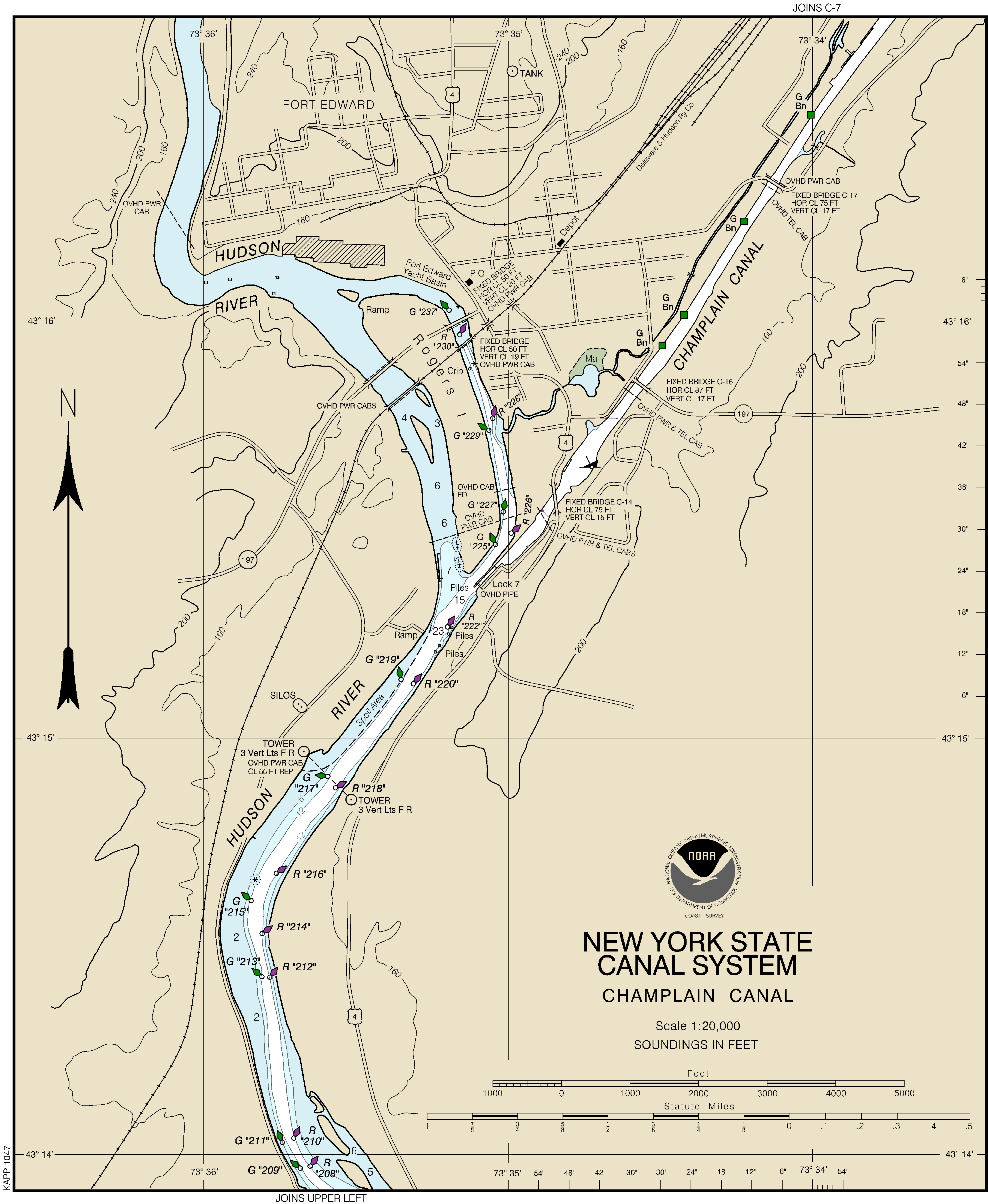
Champlain Canal – Lock 7, Fort Edward
September 8, 2014
Mariners are advised that Lock C7 Fort Edward has been reopened. The entire New York State Canal System, with the exception of Syracuse Inner Harbor, is open to navigation.
Chart 14786 C-6 covering the affected area can be found at http://www.canals.ny.gov/navinfo/charts/14786c06r.png.
Features along the Champlain Canal are listed by mileage at
http://www.canals.ny.gov/navinfo/navinfo.cgi?waterway=champlain.
For updates and information, please call 1-800-4CANAL4 or visit canals.ny.gov.
Champlain Canal – Lock 7, Fort Edward
September 8, 2014
Mariners are advised that Lock C7 Fort Edward has been reopened. The entire New York State Canal System, with the exception of Syracuse Inner Harbor, is open to navigation.
Chart 14786 C-6 covering the affected area can be found at http://www.canals.ny.gov/navinfo/charts/14786c06r.png.
Features along the Champlain Canal are listed by mileage at
http://www.canals.ny.gov/navinfo/navinfo.cgi?waterway=champlain.
For updates and information, please call 1-800-4CANAL4 or visit canals.ny.gov.
CANAL CHAMPLAIN - Avis aux navigateurs
Notice to Mariners
Champlain Canal - Upper Hudson River Dredging Project
September 7, 2014
All mariners are advised that the upper Hudson River dredging project, administered by the United States Environmental Protection Agency (EPA) and General Electric (GE), will be in progress during the 2014 Navigation Season between Lock C-4 in Stillwater and Lock C-8 in Fort Edward. The dredging operations are lighted, have day shapes and arrow boards displayed. Additional informational signs have been posted in the project area. Boaters should follow all instructions as indicated.
All boaters must contact the Vessel Traffic Center on VHF Channel 18A for transit information through the project area.
Activities Planned for the Week of September 8, 2014:
Barge unloading operations immediately south of Lock C-8.
Barge loading operations immediately north of Lock C-5.
Project hazard buoys marking shallow water areas just outside the navigational channel are located just north of buoy Green 133.
No Wake buoys in the land cut north of Lock 6 marking the no wake zone established in the vicinity of the Isthmus Transfer Area.
Norwegian buoys indicating shallow water areas located outside the navigational channel are located between buoy Red 72 and Red 66.
Dredging operations between approximately buoy Red 88 and Green 77.
Dredging operations between approximately buoy Red 68 and Red 66.
Backfill/capping operations between approximately buoy Green 121 and Red 118.
Backfill/capping operations between approximately buoy Green 91A and Green 89.
Note: Additional uncharted red & green navigational aids have been placed to help guide vessels through the project.
PASS WITH CAUTION - NO WAKE ZONE
Speed limits between Lock C-5 and Lock C-8 will be 5 mph in all work zones. In addition, please be mindful of your wakes and when approaching work platforms, stop all forward motion and proceed at a “No-Wake” speed. Local and state marine patrols will enforce posted speed limits.
For any questions related to the dredging project, call the EPA at (518) 747-4389 or GE at (518) 792-4087.
Features along the Champlain Canal are listed by mileage at http://www.canals.ny.gov/navinfo/navinfo.cgi?waterway=champlain
For updates and information, please call 1-800-4CANAL4 or visit canals.ny.gov.
07:15:17AM 9/7/14
Champlain Canal - Upper Hudson River Dredging Project
September 7, 2014
All mariners are advised that the upper Hudson River dredging project, administered by the United States Environmental Protection Agency (EPA) and General Electric (GE), will be in progress during the 2014 Navigation Season between Lock C-4 in Stillwater and Lock C-8 in Fort Edward. The dredging operations are lighted, have day shapes and arrow boards displayed. Additional informational signs have been posted in the project area. Boaters should follow all instructions as indicated.
All boaters must contact the Vessel Traffic Center on VHF Channel 18A for transit information through the project area.
Activities Planned for the Week of September 8, 2014:
Barge unloading operations immediately south of Lock C-8.
Barge loading operations immediately north of Lock C-5.
Project hazard buoys marking shallow water areas just outside the navigational channel are located just north of buoy Green 133.
No Wake buoys in the land cut north of Lock 6 marking the no wake zone established in the vicinity of the Isthmus Transfer Area.
Norwegian buoys indicating shallow water areas located outside the navigational channel are located between buoy Red 72 and Red 66.
Dredging operations between approximately buoy Red 88 and Green 77.
Dredging operations between approximately buoy Red 68 and Red 66.
Backfill/capping operations between approximately buoy Green 121 and Red 118.
Backfill/capping operations between approximately buoy Green 91A and Green 89.
Note: Additional uncharted red & green navigational aids have been placed to help guide vessels through the project.
PASS WITH CAUTION - NO WAKE ZONE
Speed limits between Lock C-5 and Lock C-8 will be 5 mph in all work zones. In addition, please be mindful of your wakes and when approaching work platforms, stop all forward motion and proceed at a “No-Wake” speed. Local and state marine patrols will enforce posted speed limits.
For any questions related to the dredging project, call the EPA at (518) 747-4389 or GE at (518) 792-4087.
Features along the Champlain Canal are listed by mileage at http://www.canals.ny.gov/navinfo/navinfo.cgi?waterway=champlain
For updates and information, please call 1-800-4CANAL4 or visit canals.ny.gov.
07:15:17AM 9/7/14
S'abonner à :
Messages (Atom)